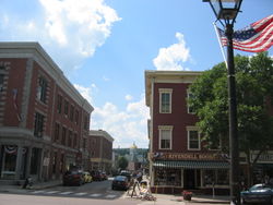
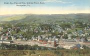
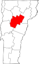
Montpelier, Vermont
| Montpelier, Vermont | |||
|---|---|---|---|
| — City — | |||
 |
|||
|
|||
 |
|||
| Coordinates: | |||
| Country | United States | ||
| State | Vermont | ||
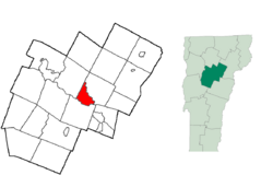
| County | Washington | ||
| Settled | 1787 | ||
| Incorporated (village) | 1818 | ||
| Incorporated (city) | 1895 | ||
| Government | |||
| - Mayor | Mary Hooper | ||
| Area | |||
| - Total | 10.3 sq mi (26.6 km2) | ||
| - Land | 10.2 sq mi (26.5 km2) | ||
| - Water | 0.1 sq mi (0.0 km2) | ||
| Elevation | 600 ft (182 m) | ||
| Population (2000) | |||
| - Total | 8,035 (city proper) | ||
| - Density | 784.0/sq mi (302.7/km2) | ||
| Time zone | EST (UTC-5) | ||
| - Summer (DST) | EDT (UTC-4) | ||
| ZIP codes | 05601-05604, 05609, 05620, 05633 | ||
| Area code(s) | 802 | ||
| FIPS code | 50-46000[1] | ||
| GNIS feature ID | 1461834[2] | ||
| Website | www.montpelier-vt.org | ||

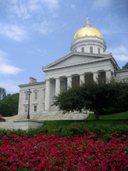
Montpelier (pronounced /mɒntˈpiːliər/[3]) is a city in the U.S. state of Vermont that serves as the state capital and the shire town[4] (county seat)[5] of Washington County. As the capital of Vermont, Montpelier is the site of the Vermont State House, seat of the legislative branch of Vermont government. The population was 8,035 at the 2000 census. By population, it is the smallest state capital in the United States.[6] The Vermont History Museum and Vermont College of Fine Arts are located in Montpelier.
Contents |
History
Chartered by the Vermont General Assembly on August 14, 1781, the town was granted to Timothy Bigelow and 58 others.[7] The first permanent settlement began in May of 1787, when Colonel Jacob Davis and General Parley Davis arrived from Charlton, Massachusetts. General Davis surveyed the land, while Colonel Davis cleared forest and erected a large log house on the west side of the North Branch of the Winooski River. His family moved in the following winter.
It was Colonel Davis who selected the name Montpelier after the French city Montpellier.[8] There was a general enthusiasm for things French as a result of the country's aid during the American Revolution.[9] The settlement grew quickly, and by 1791 the population reached 117. On November 8, 1805, the General Assembly voted to constitute Montpelier as its seat of government. The legislature met at Woodstock in 1807, then moved into its new capitol the next year. Incorporated in 1818, the village became a center for government and trade.
The town also developed into a center for manufacturing, especially after the Vermont Central Railroad opened in Montpelier on June 20, 1849—the same year East Montpelier was set off as a separate town. Falls on the Winooski River provided water power for mills, and industries produced lumber, flour, sashes and blinds, carriages, sleighs, hats and caps, furniture and silver plate. There was an iron foundry. Processing granite, mainly from the quarries in nearby Barre, was once a major part of the city's economy and continues to some degree. Montpelier had the last remaining clothespin manufacturer in the United States. It closed in 2006. Today, government and tourism are principal businesses. The Vermont History Museum, operated in The Pavilion by the Vermont Historical Society, is an attraction.
The town had the first municipal water driven hydro system in Vermont in 1884. Water pressure generated sufficient electricity for streetlights.[10]
Geography
Montpelier is located at (44.25, -72.56667)[11]. The city center is a flat clay zone (elevation ~520 ft/158 m), surrounded by hills and granite ledges. Towne Hill runs in a 2-mile ridge (~900 ft/275 m) along the northern edge of the city. Montpelier is situated among foothills just to the east of the Green Mountains.
According to the United States Census Bureau, the city has a total area of 10.3 square miles (26.6 km²), of which 10.2 square miles (26.5 km²) of it is land and 0.10% is water. The Winooski River (winooski being an Abenaki word meaning "onion") flows west along the south edge of downtown village and is fed by several smaller tributaries that cut through residential districts. Montpelier is subject to periodic flooding in the flat city center, with two major floods occurring in 1927 and 1992.
Climate
Montpelier features a humid continental climate (Köppen Dfb), with long, cold, and snowy winters, cool to mild springs and autumns, and warm summers. From January to July, highs range from 25 to 79 °F (-4 to 26 °C), and lows range from 7 to 57 °F (-14 to 14 °C).[12] Precipitation, at 35.9 inches (912 mm), is moderate, and spread fairly evenly throughout the year, though February is noticeably drier, and rainfall peaks in the summer months.[13]
| Climate data for Montpelier, Vermont | |||||||||||||
|---|---|---|---|---|---|---|---|---|---|---|---|---|---|
| Month | Jan | Feb | Mar | Apr | May | Jun | Jul | Aug | Sep | Oct | Nov | Dec | Year |
| Source: The Weather Channel (records) [12] | |||||||||||||
Demographics
| Historical populations | |||
|---|---|---|---|
| Census | Pop. | %± | |
| 1900 | 6,266 |
|
|
| 1910 | 7,856 | 25.4% | |
| 1920 | 7,125 | −9.3% | |
| 1930 | 7,837 | 10.0% | |
| 1940 | 8,006 | 2.2% | |
| 1950 | 8,559 | 6.9% | |
| 1960 | 8,782 | 2.6% | |
| 1970 | 8,609 | −2.0% | |
| 1980 | 8,241 | −4.3% | |
| 1990 | 8,247 | 0.1% | |
| 2000 | 8,035 | −2.6% | |
Along with Barre, the city forms a small micropolitan area in the center of the state; together they are known as the twin cities.
As of the census[1] of 2000, there were 8,035 people, 3,739 households, and 1,940 families residing in the city. The population density was 784.0 people per square mile (302.7/km²). There were 3,899 housing units at an average density of 380.4 per square mile (146.9/km²). The racial makeup of the city was 96.55% White, 0.65% African American, 0.24% Native American, 0.82% Asian, 0.01% Pacific Islander, 0.39% from other races, and 1.34% from two or more races. Hispanic or Latino of any race were 1.41% of the population.
There were 3,739 households out of which 26.0% had children under the years living with them, 38.5% were married couples living together, 10.1% had a female householder with no husband present, and 48.1% were non-families. 39.4% of all households were made up of individuals and 13.1% have someone living alone who is 65 years of age or older. The average household size was 2.09 and the average family size was 2.84.
In the city the population was spread out with 21.3% under the , 8.6% from 18 to 24, 28.2% from 25 to 44, 27.1% from 45 to 64, and 14.9% who were 65 years of age or older. The median age was 40 years. For every 100 females there were 84.2 males. For every 100 females age 18 and over, there were 82.0 males.
Government
Montpelier's government consists of a mayor and a city council. The city council has six members each elected from districts with each district electing two members for two year terms. The mayor is elected in a citywide vote to a two year term.
In 2008, the city discharged 3,192 pounds (1,448 kg) of phosphorus into the Winooski River, and ultimately into Lake Champlain. As part of the cleanup for the lake, the city is allowed to discharge up to 7,253 pounds (3,290 kg).[14]
Economy
Personal income
The median income for a household in the city was $37,513, and the median income for a family was $51,818. Males had a median income of $35,957 versus $29,442 for females. The per capita income for the city was $22,599. About 7.2% of families and 9.8% of the population were below the poverty line, including 12.9% of those under age 18 and 5.7% of those age 65 or over.
Industry
Since the city's establishment as capital in 1805 the primary business in Montpelier has been government, and by the mid-nineteenth century government and life and fire insurance.
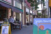
Located in Montpelier are the New England Culinary Institute, the annual Green Mountain Film Festival and the headquarters of several insurance companies. The majority of businesses in the downtown area, mostly retail, are locally owned.
Education
- Montpelier High School is the city's only high school.
- Main Street Middle School is the city's only middle school.
- Union Elementary School is Montpelier's only elementary school.[15]
- Vermont College of Fine Arts is a low-residency graduate school offering Masters of Fine Arts degrees in visual arts, writing, and writing for children and young adults.[16]
- New England Culinary Institute
- The Union Institute and University of Vermont Center Master of Education program offers education students a low-residency program that combines independent study with academic classes and workshops.[17]
Transportation

Because Vermont's founders deliberately placed the capital near the geographic center of the state,[18][19] Montpelier is one of Vermont's most readily accessible cities and towns. The city is located along ![]() Interstate 89, while east-west
Interstate 89, while east-west ![]() U.S. Route 2 and north-south
U.S. Route 2 and north-south ![]() Vermont Route 12 are two other principal routes that intersect in Montpelier. Both I-89 and U.S. 2 provide a direct link to Burlington and the populous Lake Champlain Valley in the northwestern corner of the state. In addition,
Vermont Route 12 are two other principal routes that intersect in Montpelier. Both I-89 and U.S. 2 provide a direct link to Burlington and the populous Lake Champlain Valley in the northwestern corner of the state. In addition, ![]() U.S. Route 302 has its western terminus in Montpelier, connecting it with the nearby city of Barre and points east.
U.S. Route 302 has its western terminus in Montpelier, connecting it with the nearby city of Barre and points east.
Amtrak, the national rail passenger system, provides daily service from Montpelier, operating the Vermonter between St. Albans, Vermont and Washington, D.C. Greyhound Bus Lines operates buses that serve Montpelier. The Green Mountain Transit Authority (GMTA) operates a local bus network throughout the micropolitan area, with stops in Montpelier and Barre, including nearby Waterbury, the Vermont State House, Ben & Jerry's factory, and the local Berlin Mall. GMTA and its sister bus company in Burlington, the Chittenden Country Transit Authority, operate a series of LINK commuter buses with stops in Montpelier, Burlington and Waterbury. A few small taxi companies serve the area.
Air travelers in private planes can use the Edward F. Knapp State Airport in Berlin to access Montpelier. The closest commercial air service is located 35 miles (56 km) northwest of Montpelier, at the Burlington International Airport.
Two shared-use paths for walking and bicycling connect to Montpelier: the Cross Vermont Trail and the Central Vermont Regional Path. Montpelier's downtown is relatively compact and pedestrian-friendly, with sidewalks and crosswalks throughout the downtown area.
Sports
The Vermont Mountaineers of the New England Collegiate Baseball League play at the Montpelier Recreation Field.
Cultural
An annual local vernacular culture phenomenon, the Valentine Bandit, a tradition of covering downtown storefronts and public buildings with red hearts each February 14, began in Montpelier in the 1990s.
- Kellogg-Hubbard Library—with a copy of the Parthenon frieze[20]
- Lost Nation Theater[21]
- Montpelier Theatre Guild[22]
- Vermont History Museum—in The Pavilion[23]
- Vermont State House
- T. W. Wood Gallery & Arts Center[24]
Notable people
- Frederick W. Adams, physician and author.
- Michael Arnowitt, classical and jazz pianist.
- George W. Cate, congressman.
- Richard A. Cody, general.
- Jessica Comolli, beauty queen.
- Kathryn Davis, award-winning novelist.
- Hannibal Day, army officer.
- George Dewey, admiral.
- William Charles Fitzgerald, naval officer.
- Alison Goodwin, artist.
- Garrett Graff, editor and educator.
- Mary Hooper, mayor.
- Vincent Illuzzi, politician.
- Jim Laird, football player.
- Patrick Leahy, senator.
- Frank Miller, comic book writer and artist.
- Lucas Miltiades Miller, congressman from Wisconsin.
- Anais Mitchell, singer/songwriter.
- Asahel Peck, governor of Vermont.
- Samuel Prentiss, senator.
- Arthur E. Scott, photo-historian of U.S. Senate.
- John Mellen Thurston, senator.
- Samuel C. Upham, journalist and counterfeiter.
- William Upham, senator.
- Eliakim Persons Walton, congressman.
- Charles W. Willard, congressman.
- Thomas Waterman Wood, painter.
- Eric Zencey, novelist and essayist.
See also
- Athenwood and the Thomas W. Wood Studio
- Christ Episcopal Church
- Montpelier City Hall
- Montpelier Recreation Field
- Saint Augustine's Church
References
- ↑ 1.0 1.1 "American FactFinder". United States Census Bureau. http://factfinder.census.gov. Retrieved 2008-01-31.
- ↑ "US Board on Geographic Names". United States Geological Survey. 2007-10-25. http://geonames.usgs.gov. Retrieved 2008-01-31.
- ↑ Montpelier - Definitions from Dictionary.com
- ↑ Title 24, Part I, Chapter 1, §13, Vermont Statutes. Accessed 2007-11-01.
- ↑ "Find a County". National Association of Counties. http://www.naco.org/Template.cfm?Section=Find_a_County&Template=/cffiles/counties/usamap.cfm. Retrieved 2008-01-31.
- ↑ Smallest capital city plans big MLK celebration. Retrieved 2010-04-23.
- ↑ "History". The Montpelier Master Plan Task Force, Department of Planning and Development (March 1997). City of Montpelier, Vermont. 2004-03-06. http://www.montpelier-vt.org/history/index.cfm. Retrieved 2007-02-12.
- ↑ Federal Writers' Project of the Works Progress Administration for the State of Vermont (1996). Vermont: A guide to the Green Mountain State. The Stephen Greene Press. pp. 117.
- ↑ Swift, Esther Munroe (1977). Vermont Place Names: Footprints of History. Houghton Mifflin. pp. 451–454. ISBN 0-8289-0291-7.
- ↑ Barg, Lori (9 August 2009). "Power from the plumbing". Burlington, Vermont: Burlington Free Press. pp. 5D.
- ↑ "US Gazetteer files: 2000 and 1990". United States Census Bureau. 2005-05-03. http://www.census.gov/geo/www/gazetteer/gazette.html. Retrieved 2008-01-31.
- ↑ 12.0 12.1 "Average Weather for Montpelier, VT - Temperature and Precipitation". http://www.weather.com/weather/wxclimatology/monthly/graph/USVT0147?from=search. Retrieved 2009-01-03.
- ↑ Cite error: Invalid
<ref>tag; no text was provided for refs namedNCDC - ↑ Page, Candace (9 July 2009). "Sewage:Judge sides with CLF, throws out Montpelier permit". Burlington, Vermont: Burlington Free Press. pp. 4A.
- ↑ Union Elementary School
- ↑ Vermont College of Fine Arts
- ↑ Union Institute and University of Vermont Center M.Ed. Program
- ↑ Vermont geography
- ↑ Vermont capitol
- ↑ Kellogg-Hubbard Library -- with a copy of the Parthenon frieze
- ↑ Lost Nation Theater
- ↑ Montpelier Theatre Guild
- ↑ Vermont History Museum -- in The Pavilion
- ↑ T. W. Wood Gallery & Arts Center
External links
- City of Montpelier, Vermont
- Kellogg-Hubbard Library
- Central Vermont Chamber of Commerce
- State of Vermont
|
|||||||||||||||||||||||
|
|||||||||||||||||||||||
|
||||||||||||||
|
||||||||